Vertical Logic

Wednesday, September 16, 2015

Utah 13ers

The Utah 13ers are all located in the remote Uinta Mountains. Before this adventure I had never set foot in the High Uintas Wilderness. Jason Dorais and Lars Kjerengtroen a few weeks prior took down the FKT on the roof of Utah, Kings Peak. They brought back some stoke on the Uintas. According to summitpost.org some of the peaks are 40 mi round trip just for one. This seems like a touch of hyperbole now that I know the area, but the approaches are long. So why not make the miles count and tick them all off in a single outing? From my naive position, this seemed completely reasonable. So we set plans into motion to test the theory.

The first issue encountered in recon is the number of peaks. There are numbers ranging from 17 to 21 13,000' peaks depending on the level of prominence considered. David Rose's book Utah Thirteeners is by far the best resource for beta. However, the book does not seem to be rigorous in its usage of names -- as many do not have official names the author gave his own nicknames further adding to the confusion. Fortunately the route is straightforward enough. All of the discrepancies can be ironed out by hitting every bump on the prominent ridges with only 2 small exceptions.

Group 1: Tokewanna Peak, "NW Wasatch" (aka "Mount Wapiti"), "Wasatch Benchmark", Mount Lovenia, "East Lovenia" (aka "Quandary Peak")

Group 2: Wilson Peak, Mount Powell

Group 3: Gilbert Peak, "Gunsight Peak", "West Gunsight (aka "Dome Peak"), "Henry's Fork Peak" (aka "Fortress"), "Cliff Point"

Group 4: Kings Peak, South Kings Peak, "Second Gemini", "Painter Peak" (aka "First Gemini"), "Trail Rider Peak" (aka "Ramp Peak"), "Roberts Peak" (aka "Pyramid Peak"), "North Mount Emmons" (aka "Pinnacle Peak"), Mount Emmons, "South Mount Emmons" (aka "Glacier Peak")

The only question marks on the route: are "Cliff Point" and "South Mount Emmons" prominent enough to extend the route for them? "Cliff Point" was only about 100 ft above the saddle between it and "Henry's Fk Pk", but it was so close we decided to hit it anyways. "South Mount Emmons" only has 270 ft of prominence from the saddle between it and Mount Emmons, but it seems logical enough to hit as well. All others either have well over 300 ft of prominence or sit on a ridge we would have travel over anyways.

The route would start at the trailhead gate at the end of the road in West Fork Blacks Fork in the north, tackle each group as ordered above and then exit Swift Creek to the south. Roughly 60 miles and 23,000' of ascent.

Check the route in --------------------------------------------------------------------------------------------------------------------------

Jason and Lars were chomping at the bit to get this one done before the fall arrived. Unfortunately for Lars, it became clear that an injury to his foot prevented him from being able to do much scrambling and was out for the near future. Jason and I picked a date on the calendar (9/9 and 9/10) and hoped for good weather. Lars probably hoped for the opposite (sorry buddy!).

As the dates got closer, the weather looked perfectly stable and dry. Despite a minor illness on Jason's part and some recent travel for work on mine, things seemed to align well.

We decided to prepare for 30-40 hours -- I packed warm clothes, 6000 calories and 1.75L of liquid capacity.

--------------------------------------------------------------------------------------------------------------------------

Jason picked me up at 6:30am. We stuffed our faces with food and drink on the drive to W Fk Blacks Fk and began the adventure promptly upon arrival (9:30am). Jason took great pleasure signing into the trailhead register and putting Swift Creek as the destination.

We strolled casually through the first miles of trail and a herd of sheep. Fortunately the sheep dogs were only barking far in the distance. Then after a mile or so we turned up to gain the ridge below Tokewanna. We tagged the summit in under 2.5 hrs and proceeded south along the ridge.

Jason on the summit of Tokewanna
The first day went splendidly, moving at an easy pace with a full stomach. Before we were on the route, there was some concern about the way off of East Lovenia. In full daylight navigation was simple, including the Lovenias. We were off of the first group and having a water filtering and dinner stop shortly after 5pm in the Oweep Valley.

On our way to Red Knob Pass with Mount Lovenia in the background


On the ridge to East Lovenia
We made the 5 mi trek up valley on and adjacent to Highline trail as it was not always easy to follow. We gained Porcupine Pass and left the trail to tag Wilson Peak. We lost the sun and twilight just as we reached the summit. While on the summit, I cracked the LCD on my phone rendering it useless and had to stop my watch because it was getting low. We would need the watch for navigation later in the night.

The descent off Wilson was the first time it felt like we slowed down significantly. We took some time staring into the darkness deciding how to navigate the loose steep descent toward Smiths Fork Pass. In the end it was pretty easy, but the darkness made every decision take longer.

More on the ridge to East Lovenia -- photo by JD
We took a brief stop for food near Smiths Fork Pass. We noted the stars looked like nothing we had seen before, so bright and so many stars. Then we began climbing the long ridge up to Mount Powell.
Uneventful exit off East Lovenia


View from dinner location.

The footing on the lower ridge was the nicest so far with some grass between the rocks. This was short lived however and it was back to talus hopping along an undulating ridge.

Once on the summit of Mount Powell we tried to spy our descent into Henry's Fork. In the dark the bowl was much larger and more wide open than anticipated. It seems to take forever to navigated the large talus. In the end it was a lot of what we could expect the rest of the trip, but at the time it felt heinous.

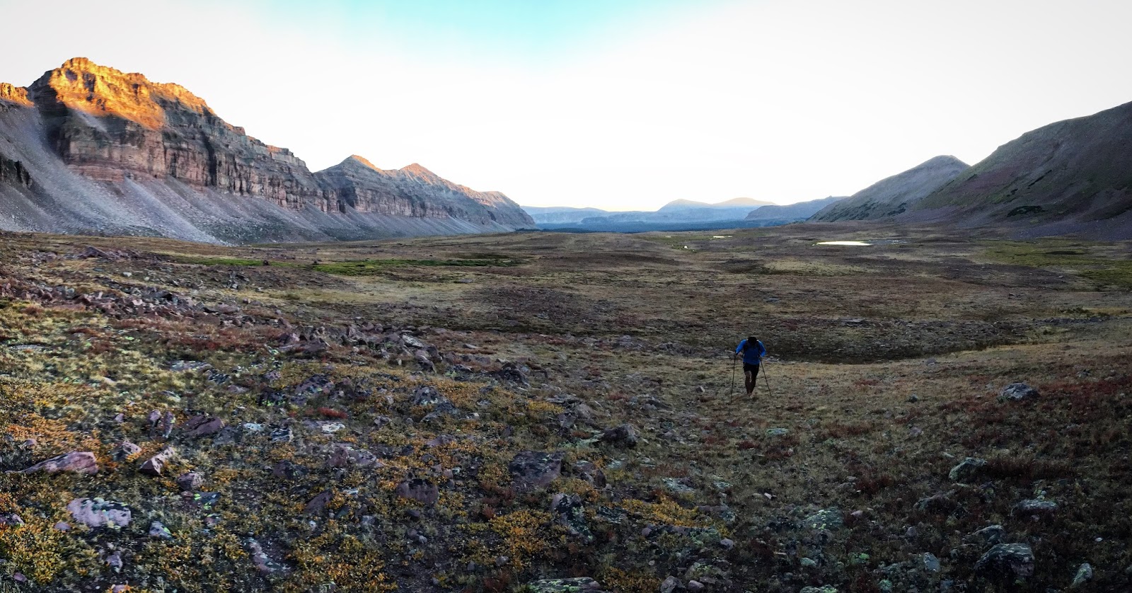
Jason in the Oweep Valley before sunset

Once into Henry's Fork we stopped for a water fill up and food again. It was now after 1am and we began the 3 mile trek across the basin. This started out easy and slowly began to get more unpleasant in terms of the terrain. Small creek crossings became larger and more numerous. Small willows turned into giants. Eventually we were wasting a lot of time and energy trying to find the paths of least resistance. Cold air was setting in and standing water was freezing. Just before the Henry's Fork Trail we topped off water -- we also knew this would likely be our last fill up until reaching Swift Creek drainage. This would end up being more than 14 hours later!

We reached the Henry's Fork trail and took it south to just below the gully we chose to ascend for Gilbert Peak. It was now 3am! We decided to take a quick 15min nap before ascending Gilbert. I woke up shivering before Jason's alarm went off. The first 1000ft up the gully was the first time I felt real fatigue in my legs. Once out of the gully the angle yields to an easy grade. Gilbert is riddled with false summits and made worse by the darkness.

We summited Gilbert and made our way toward Gunsight. Twilight was beginning to show on the horizon. After topping out Gunsight we could put away the headlamps. The sun rose on our descent to Gunsight Pass.

In the early morning, partially due to the cold and partially to rationing water I had ate and drank much less. The climb up West Gunsight was awful for me. I decided to gamble on feeling good more immediately than later in the day and ate and drank a large portion of my remaining liquid and calories.

From Anderson Pass, I started to feel better on the out and back to Henry's Fork Peak and Cliff Point. Kings Peak hurt a bit, but I also knew this would be the largest climb remaining (though similar to Emmons).

South Kings was probably the easiest summit so far (not counting Cliff Point). At this point we began to feel that we would get the remaining done without a complete sufferfest. The rest of the summits after South Kings went in a predictable fashion: move quickly and fluidly as possible over the descending and flat talus riddled terrain, suffer for a few hundred vertical to get to the next summit, sit down and pause on the summit before starting it all over again.

Pretty soon we were on the top of North Mount Emmons looking at the two remaining (Emmons and South Mount Emmons) in very good moods. At this point though we were both out of water in the blazing sun, the hottest of the trip.

We made good time up Emmons, despite our state and its many false summits -- something we had come to expect from the Uintas at this point. On our way over to South Mount Emmons to finish the peaks, there was a cool scene with this mountain goat standing on a diving board of a rock watching us from above.

The descent into Swift Creek ended up being pretty horrible. Jason had read of some possible trail, but we found none. Instead we dropped steeply into the valley on horribly loose talus of varying sizes.

Jason beat me on the race to the nearest stream! As I got to him I asked if had seen the tents to our right as we descended as I thought they might be near the trail. He said no, but went to go check it out as I filled up my water. He came back a bit later yelling something about rocks. Apparently they weren't tents at all, but rocks! We had a pretty good laugh over the fact that he started talking to the "tents". This began our weak hallucinations for the rest of the trip, seeing patterns or objects in our surroundings which were not real.

The Swift Creek valley is much wider to the north, so instead of trying to cross the valley immediately we decided to take advantage of the easy travel and head south before trying to find the trail.

At some point we decided to head west to try and find the trail but we found none. I thought it could have been to the west of the creek so we switched over, but could not find it. The light was fading at this point so we dared not venture far from the creek which would also take us to the trailhead.

The bushwacking got much worse, the stream became more gorged out and difficult to walk next to, it was getting dark and we probably had another 5 miles to go. Things were looking grim. At some point we came across a beaver pond with a dam. We stopped to debate which way to go, and ultimately decided to walk across the dam. Once on the other side we walked a few hundred feet and there it was, the trail!

The rest was easy... or at least I'd like to think so. The truth is, I felt pretty crappy the last mile or two and was cursing the amazing trail we were on for its switchbacks and other nonsense. But finally we arrived at the trailhead, found Amanda waiting for us, gave some high fives and agreed "Let's never do that again."

--------------------------------------------------------------------------------------------------------------------------
Splits below recorded with our Spot:


Date and Time Location
Lat
Long
09/09/2015 09:28:54 W Fk Blacks Fk TH
40.83625
-110.64806
09/09/2015 11:51:09 Tokewanna Peak
40.81007
-110.62367
09/09/2015 13:03:43 NW Wasatch
40.79274
-110.63599
09/09/2015 13:38:12 Wasatch Benchmark
40.78117
-110.62457
09/09/2015 15:03:49 Mount Lovenia
40.75683
-110.60707
09/09/2015 16:06:10 East Lovenia
40.76269
-110.58321
09/09/2015 20:36:40 Wilson Peak
40.77591
-110.46172
09/09/2015 23:04:35 Mount Powell
40.796
-110.42497
09/10/2015 04:55:05 Gilbert Peak
40.82347
-110.34018
09/10/2015 06:20:29 Gunsight Peak
40.80342
-110.35266
09/10/2015 07:41:42 West Gunsight
40.79285
-110.36659
09/10/2015 08:45:53 Henry’s Fork Peak
40.78784
-110.38985
09/10/2015 09:00:26 Cliff Point
40.78856
-110.39548
09/10/2015 10:11:10 Kings Peak
40.77635
-110.37294
09/10/2015 10:52:48 South Kings Peak
40.7659
-110.37793
09/10/2015 11:29:43 Second Gemini
40.75512
-110.36929
09/10/2015 11:55:34 Painter Peak (First Gemini)
40.75311
-110.35895
09/10/2015 12:37:20 Trail Rider Peak
40.74193
-110.35228
09/10/2015 13:23:03 Roberts Peak
40.73562
-110.33928
09/10/2015 14:29:10 North Mount Emmons
40.72252
-110.3179
09/10/2015 15:18:29 Mount Emmons
40.71177
-110.3038
09/10/2015 16:00:07 South Mount Emmons
40.7037
-110.31203
09/10/2015 21:47:52 Swift Creek Trailhead
40.6013
-110.34763

Total duration: 36 hours, 18 minutes, 58 seconds.

Spot GPX data uploaded to Strava:


Critical Gear:

Shoe: La Sportiva Mutant
Puffy: La Sportiva Valhalla Jacket
Wind Layer: La Sportiva Hail Jacket
Glasses: Julbo Dust

Update: Jason's account may be found here.


Sunday, August 9, 2015

The Adirondack Great Range Traverse FKT

Breaking the radio silence on here. Hopefully I will do a better job in updating this journal going forward than I have recently. Much has happened that is noteworthy since my last post, but as is customary here is my report of a recent FKT attempt.

At some point a little over a year ago I learned of the Adirondack Great Range Traverse while looking up potential steep run training while on an extended family vacation at my parents' lake house in the Adirondacks. In complete ignorance I decided to give it a try a week after Speedgoat 50k. For some reason I took only 20oz of water, no food and wore new shoes. As you might guess everything went south pretty badly... at around the 3 hour mark. The nature of the trail as anyone who has done it is steep terrain both up and down. There is a mix of wooded (i.e. rooted) terrain, then nice slabs and heinous mini boulders especially toward the Marcy end of the route. I ended up limping in to the Garden trailhead in 8hrs finding Dominique very relieved after I totally blew my time estimates.

Flash forward a year, and another trip to see my family I was committed to redeeming myself on this route. I noticed that the FKT had just been dropped to 5:49 by one of the then two record holders (5:56) in June. After some big vert days 10-13k ft and a 42k ft week in my legs from recent training, I checked the splits, the VAMs and even did a mini taper coming to NY (though I think I always "taper" when I'm at the lake). I had convinced myself that maybe the FKT was in reach if I could hold it together on the final descent.

On Saturday August 8, 2015 I set off from the Rooster Comb TH just before 7:30am. The temperatures were right around 50F a nice contrast to current UT weather. Within the first few minutes I had convinced myself I felt good! I tried to keep the reins in check, but ultimately I arrived at Rooster Comb faster than intended (28:58) running every step. My MO is definitely to start too fast, but I also knew the early sustained climbs were my best terrain. The next long section through Hedgehog and then Lower Wolfjaw (LW) really suited my style -- mostly steep hiking. I was a bit torn between the tradeoffs of starting fast. But when I hit the LW split 1:17:50 I gained confidence that I wouldn't lose time with my restrained pace and decided to settle in until Gothics before digging deep.

Upper Wolfjaw (1:40:49), Armstrong (1:54:29) and Gothics (2:08:16) came and went in an awesome state of flow. The descent off Gothics is beautifully steep slab and the first taste of alpine in comparison to the earlier peaks and what is to come. At this point I was really soaking it in and realizing the potential for a great day. As promised, I told myself I'd turn the discomfort up for Saddleback (2:27:47) and then Basin (2:47:14).

Low clouds had surrounded me all morning and kept me cool, though the unfamiliar humidity made me very damp from sweat. I had drank less than I anticipated. With one of two bottles empty I was happy to conserve some liquid calories when I arrived at the small creek between Basin and Haystack. I quickly sucked back 20oz or more with my lifestraw, ate some calories and took off again feeling able to push the climb.  The turn for Haystack came much quicker than anticipated and only buoyed my mood. Once onto the slabs below the summit I started to dig just a bit more. I hit the summit of Haystack in 3:24:14.

The descent off Haystack and climb up Marcy went equally well, still feeling able to push albeit a touch more labored. I tried not to look at my watch until I hit the summit and when it read 4:05:35 I knew the FKT was mine to lose. Descending that terrain isn't in my typical running program and 9mi of washed out, bouldery creek-bed-like trail was a bit daunting. I tried to go smooth and controlled, but I felt the time leaking out with every step. Eventually the trail eased and while still littered with roots and rocks it was much more runnable. I passed the Johns Brook Lodge at 5:15:18 feeling relieved that the FKT was still in reach but also completely aware of the time hemorrhaged. I pushed the last 3mi as best I could and arrived to meet Dominique at the Garden in 5:44:21 and much better circumstances than last year!

Movescount GPS: http://www.movescount.com/moves/move72099143
Strava Details: https://www.strava.com/activities/364488662/overview


Friday, July 31, 2015

Lone Peak FKT

Ran up Lone Peak from Jacob's Ladder on July 31, 2015. I left the car just after 6am in time trial mode. Reached the summit in 1:37:15 for a new ascent FKT (jogged down in 2:59:41 car-to-car).

Movescount GPS: http://www.movescount.com/moves/move71113366
Strava: https://www.strava.com/activities/358100755/overview

Saturday, March 28, 2015

Pfeifferhorn Car-to-car FKT

On March 28, 2015 I set out to try for the car-to-car FKT on the Pfeifferhorn from White Pine trailhead. On skis I set out on the summer route up Red Pine. I switch to booting with skis on back just before the summit. I reached the summit in 1:27:22. On the descent I opted to skip the scramble and descended into Maybird and then traversed back to Red Pine. I reached White Pine TH in 1:52:13.

Movescount GPS: http://www.movescount.com/moves/move57350986
Strava: https://www.strava.com/activities/275543843/overview

Tuesday, December 10, 2013

Irwin Skimo Race

The photos of skiing in Crested Butte were enough to provoke jealously all Fall. Adding Irwin to this winter's race calendar seemed like a no brainer because of the conditions. Complete with a cat ride to a full backcountry race, an awesome post race party with the CB crew and a powder day on Sunday -- all expectations were exceeded.

The Irwin ambience
The Race

My favorite slippers
The morning was cold, but not as cold as expected earlier in the week -- around zero with light wind and snow. After a quick change into boots under the La Sportiva tent and warmup I towed the line with the rest.

The first climb started up a low angle cat track for the first 400 ft vertical, suitable for the drag race. I took the holeshot and focused on good technique, getting some glide instead of the inefficient jog. The breathing and gear clatter decreased as the race unfolded. Once we exited off the cat track we started up a skin track set the day before. There was now a couple inches on the skinner.


Not wanting to give up the work I had put in off the start, I kept some pressure on. At the first kick turn I saw Marshall Thomson, John Gaston and Brian Smith behind me. Once we got above treeline, about 1k ft of climbing I sensed that the race was coming back together without a fresh skintrack. I stepped aside to let Marshall take a pull. The last 500 vertical of the first climb provided more trail breaking for Marshall and a good opportunity for the rest of the field to hitch back up.

Lots of spandex in the backcoutnry
At the first transition John took off first, followed by myself. In the flat light John went down in some variable snow. I lead until the flat just above the trees where Max Taam came by. The mellow powder run was a blast. Max, myself then Brian arrived at the bottom transition (adjacent to the start/finish line). Brian got the jump on me to the start of the second climb.

We were treated to a fresh skintrack and the race was on. I followed on Brian's heels and we made an efficient ascent through the forest. Unfortunately we caught the individuals freshening up the skinner in less than 1000 ft vertical. The course then made some kick turns up to the booter. Towards the base of the bootpack I stepped out of my binding on some firm snow. I frantically messed with it and tried to catch back up to Brian.

The booter itself was very short -- 100 ft vertical or so. We switched back to skinning from the top of the booter. Unfortunately again there was significant trail breaking from the overnight snow and winds. The race came back together. Notably John had caught back up.

I got the jump out of transition but was quickly passed by Brian, Max and John on the powdery flats, at which point I hitched a ride on the train. At the bottom we all arrived within seconds of each other.

I had a good transition and was out first, stepping over ski tails and poles as I squeezed my way from the back of the transition zone. Brian and John followed closely. I threw down what I had left on the next 900 ft vertical. The third climb hadn't been freshened up either and when I hadn't dropped Brian or John I gave them a turn, hoping to recover for a final move and preserve the gap we now had over Marshall and Max.

Brian took a pull and then John. At the top of the climb instead of making a move I was on my heels. At the transition John was gone as I started to rip my first skin and Brian was gone when I ripped the second.

The third descent was steeper up top and had nearly a mile of double poling and skating to the finish line at the bottom. My legs protested on the final descent and the double poling on unsupportable snow was painfully slow. Finally I hit the cat track for the start of the skate. Only one set of tracks was on the snow in front of me. Shortly after though Brian, a strong nordic skier, passed me. Despite a hard effort that was how it remained -- losing to Brian by 5 seconds and John 28 seconds.

Post Race

One of the funniest stories of the race was that Brian and I somehow switched poles in one of the transitions (bottom of the second descent?). Fueling the narrative further, my poles are 5 cm longer -- for a shorter guy a convenient length for the skate to the finish! Honestly I never noticed the whole time, but it makes an entertaining story.

The post race party at the Brick Oven in CB was fantastic as well. Free pizza, beer and hours of talking skiing! Does it get any better? Put this race on your calendar next year.

Thanks to Wick and the other race org for a great event. Looking forward to other trips to CB this winter for more racing.